
Ramban Flash Floods & Hailstorm: What Caused Overnight Deluge in Jammu And Kashmir?
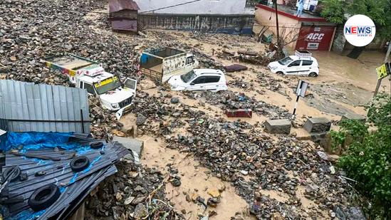
Even as temperatures soared to 44℃ in the plains of Northwest India, intense heavy rainfall and hailstorm pounded parts of Kashmir region on Sunday with winds gusting up to 40-50 kmph intensifying the damage. Over 60 mm rainfall fell in just two hours in the Ramban district situated on the banks of Chenab river triggering flash floods and devastating landslides.
As of Monday morning, the extreme weather has killed at least three people, while a few remain missing as the rescue operations continue. More than 100 people from the adjoining villages have been rescued so far, as the deluge has swept away houses, shops and damaged local infrastructure. A detailed assessment is awaited, but local reports suggest that parts of Jammu-Srinagar highway have also been blocked.
“It was not technically a cloudburst, but intense heavy rain caused by a high-intensity weather system,” said Mukhtar Ahmed, senior meteorologist and director, IMD Srinagar, referring to the intense weather disturbance which impacted the north-western Himalayas, and caused heavy rains over Jammu & Kashmir, Ladakh, Gilgit-Baltistan & Muzaffarabad.
“Nearly 60 mm rainfall was recorded over Ramban in just two hours. The topography of the region is such that a strong spell of rain can trigger massive mudslides and landslides. The region is highly vulnerable to flash floods. Normally, we do not expect heavy rain/snow during this time, but it depends on the formation of weather systems,” Ahmed told. Bandipora recorded 30 mm rain.
The IMD had earlier warned of an approaching western disturbance till April 20, with peak intensity on April 18 and 19. The temperatures had plummeted significantly across the Kashmir-Ladakh region over the past few days with a fresh spell of snowfall in the upper reaches, and hailstorm hitting many areas. The freaky weather also affected the local crops, especially apple blossoms and horticulture production.
Such was the intensity of the western disturbance that its impact was felt also over neighbouring Himachal Pradesh where many districts from Shimla, Sundernagar, Kangra, Kalpa to Bhunter experienced intense thunderstorms and gusty winds. Snowfall was also recorded in Hansa and Keylong situated in the Lahaul and Spiti districts. Pooh in Kinnaur saw the maximum rainfall of around 48.2 mm in the state.
What Are Flash Floods?
Flash floods occur due to excessive or continuous rainfall over a period of days, or during particular seasons, which can lead to stagnation of water. The US’s meteorological agency, the National Weather Service, says flash floods are caused when rainfall creates flooding in less than six hours. It adds that flash floods can also be caused by factors apart from rainfall, like when water goes beyond the levels of a dam.
In India, flash floods are often associated with cloudbursts – sudden, intense rainfall in a short period of time. Most Himalayan states face the challenge of overflowing glacial lakes, formed due to the melting of glaciers.
Flash flooding commonly happens where rivers are narrow and steep, so they flow more quickly, as per the Met Office, UK’s national weather service.
What Are Western Disturbances?
Western Disturbances are these extra-tropical storms which originate from the Mediterranean Sea and travel eastwards. They bring rain/snow over northwest India once they impact the Himalayas. Extratropical storms are a global phenomenon that carry moisture in the upper atmosphere, as opposed to tropical storms, which carry moisture in the lower atmosphere.
During the winter, western disturbances become more frequent and stronger.
The latest forecast suggests the weather system has passed, and the intensity of rainfall is gradually falling, however parts of Himachal Pradesh may experience hailstorm in some areas.
What Is MeT Prediction?
The MeT has warned of isolated to scattered rain, lightning and gusty winds for the next 24 hours in the Kashmir region, following which the weather is likely to remain dry. Another fresh western disturbance is likely to impact the western Himalayan region on April 24.
The maximum temperatures are currently above-normal in many parts of Kashmir region peaking at 31.5℃ in Muzaffarabad (Kashmir), and 36.6℃ in Kathua (Jammu). The minimum temperatures also remain above-normal, with the lowest of 0.6℃ in Gulmarg (Kashmir) and 6.6℃ in Banihal (Jammu).